GeoEditor
About GeoEditor
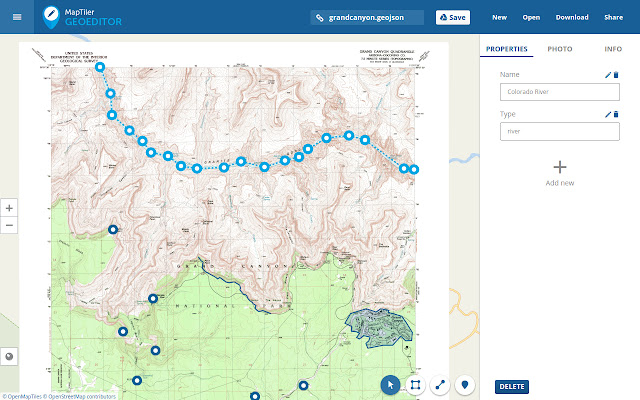
Display your own maps maps generated by MapTiler (http://www.maptiler.com).
The app supports GeoJSON format and synchronization via Google Drive for basic sharing of the data with other people! Perfect for data collection for GIS and surveys.
It is easy to import scanned hiking maps, PDF maps, drone aerial imagery, nautical charts for sailing and navigation with a boat or a yacht, fishing maps, aeronautical charts for flight planning by pilots, parcels and city plans and other opendata from local government. Vector base maps are powered by OSM2VectorTiles. Maps can come from existing tile servers with TileJSON or XYZ tiles.
Supported geodata formats by MapTiler: GeoTIFF, TIFF, JPEG, ECW, SID / MrSID, NOAA KAP / BSB, DEM, OziExplorer OZI OZF2 & OZFX3, WebP, JP2, JPEG2000, GeoJP2, Erdas, Grass, Safe, Sentinel2, SRTM, NASA imagery, USGS map sheets, exports from ESRI ArcGIS, ArcSDE, etc.
The GeoJSON can be converted from / to: ESRI ShapeFile, DXF, DWG, GPX, CSV and KML.
Why Download GeoEditor?
- ✅ Trusted by 1000+ users worldwide
- ✅ High Rating: 4/5 stars from 6 reviews
- ✅ Latest Version: 1 - Always up to date
- ✅ Safe & Secure: Verified by Chrome Web Store
- ✅ Free to Use: No cost required
Extension Details
Discover GeoEditor - The Best Chrome Application for Your Browser
Looking for the perfect Chrome application to enhance your browsing experience? GeoEditor is one of the most popular and highly-rated applications available on the Chrome Web Store, trusted by over 1000 users worldwide.
With an impressive 4-star rating based on 6 authentic user reviews, GeoEditor has proven its value and reliability to the Chrome community. This application is perfect for users who want to improve their productivity, enhance their browsing security, or simply add useful functionality to their Chrome browser.
Download GeoEditor today and join thousands of satisfied users who have already discovered the benefits of this powerful Chrome application. Installation is quick and easy - simply click the download button above to be redirected to the official Chrome Web Store where you can safely install this extension in just a few clicks.
Similar applications